01 Where do the Sangre de Cristo Mountains begin and end?
The range begins at Poncha Pass, in south-central Colorado, and runs south and southeast for roughly 242 miles until it gives out at Glorieta Pass, a few miles southeast of Santa Fe. At its widest it spreads about 120 miles from east to west. It is the last stretch of the Rocky Mountains before the basins and mesas of New Mexico take over, so the ridgeline you see when you stand on the Plaza and look east is very nearly the end of the Rockies.
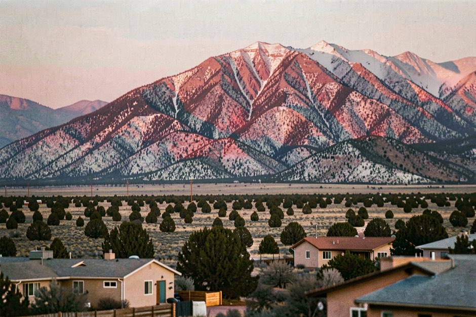
Over that distance the mountains carry several local names. From north to south, geographers list the Sangre de Cristo Range proper, the Crestones, the Culebra Range, the Taos Mountains, the Cimarron Range, the Rincon Mountains and, last of all, the Santa Fe Mountains, which take in every peak south of New Mexico Highway 518. The Spanish Peaks stand just east of the Culebra Range and are counted with the Sangre de Cristo by some writers and kept apart by others.
Glorieta Pass, at about 7,500 feet, is where the mountains finally let a road through. The westernmost leg of the Santa Fe Trail used it, the railroad followed in 1879, and Interstate 25 crosses it today. From 26 to 28 March 1862 it was also the scene of a Civil War battle, and parts of that battlefield are now preserved in Pecos National Historical Park.
02 Why is the range called the blood of Christ?
Sangre de Cristo is Spanish for the blood of Christ. Nobody has established for certain who first applied it to these mountains, but the name has been in use since the early nineteenth century. Before that, Spanish speakers in New Mexico called the range La Sierra Nevada, La Sierra Madre or simply La Sierra: the snowy range, the mother range, the range. English-speaking travellers sometimes called them the Snowies.
The usual explanation is the light. At sunrise and sunset, and above all when snow lies on the summits, the slopes can turn a deep red or rose, an effect known as alpenglow. From Santa Fe the geometry works in your favour: the mountains lie to the east, so the last light of the day falls squarely on the faces that look down on the city. A clear evening after a snowfall is the time to watch for it.
There is also a legend that the words were the last ones spoken by a dying priest in these mountains. It is a legend, it cannot be checked, and it is best enjoyed as one.
03 The high points, from Colorado to Santa Fe
The range is highest at its northern end and loses height as it runs south, though not by much. Several summits in the Colorado section pass 14,000 feet; the New Mexico section tops out just above 13,000, and the peaks directly above Santa Fe still clear 12,000.
| Summit | Where | Elevation | Why it matters |
|---|---|---|---|
| Blanca Peak | Southern Colorado, above the San Luis Valley | about 14,350 ft | Highest point of the whole range |
| Wheeler Peak | Taos Mountains, New Mexico | 13,161 ft | Highest point in New Mexico |
| Pueblo Peak | Taos Mountains, New Mexico | 12,305 ft | Rises directly above Taos Pueblo |
| Truchas Peak | Santa Fe Mountains, Pecos Wilderness | just over 13,100 ft | Second highest in New Mexico; truchas means trout |
| Santa Fe Baldy | Santa Fe Mountains | 12,622 ft | Highest of the summits directly above the city |
| Lake Peak | Santa Fe Mountains | about 12,400 ft | The Santa Fe River begins in the basin below it |
Two habits help when reading these figures. First, published elevations for the same summit often differ by a few feet, depending on the survey and the datum it uses: Wheeler Peak appears as both 13,161 and 13,167 feet, and Truchas Peak varies in the same way. Second, the number that matters for a visitor is the difference. The Plaza sits at 7,199 feet, so the crest above town stands more than 5,000 feet higher, all of it inside twenty miles.
04 How did the range form?
The Sangre de Cristo were pushed up during the Laramide orogeny, the long episode of mountain building that raised much of the Rocky Mountains. Their abrupt western wall came later. On that side the range is bounded by the Rio Grande rift, a belt where the crust has been stretching and dropping; on the east it is bounded by a series of reverse and thrust faults. Geologists put the vertical movement along those faults at no less than about 13,800 feet.
You can see the result from a car. North of the state line the rift holds the San Luis Valley, broad, flat and dry: the town of San Luis, Colorado, receives only about 9.6 inches of precipitation a year. The mountains rise straight out of it. At their foot lies Great Sand Dunes National Park and Preserve, whose dunes the National Park Service describes as the tallest in North America, built from sand that the prevailing winds carry across the valley floor into a pocket at the foot of the range.
In New Mexico the same rift holds the valley of the Rio Grande, and the old villages of the High Road sit in the foothills between that valley and the peaks.
05 What are you looking at from Santa Fe?
The mountains behind the city are the Santa Fe Mountains, the southern end of the whole range. The crest visible from town carries Santa Fe Baldy at 12,622 feet, Lake Peak at about 12,400 and a line of other summits above 12,000. Behind that crest lies the Pecos Wilderness: 223,667 acres of protected high country across the Santa Fe and Carson national forests, ranging from 8,400 feet to over 13,000, with about fifteen lakes.
The range is also the city's water. According to the City of Santa Fe, the Santa Fe River begins at Santa Fe Lake, below Lake Peak, and runs 46 miles down to the Rio Grande at Cochiti Pueblo. Its flow is held in the McClure and Nichols reservoirs and supplies approximately 37 percent of the city's drinking water. The upper basin, the 17,200-acre Santa Fe Municipal Watershed, has been closed to the public under a 1932 order from the Secretary of Agriculture, updated in 1991.
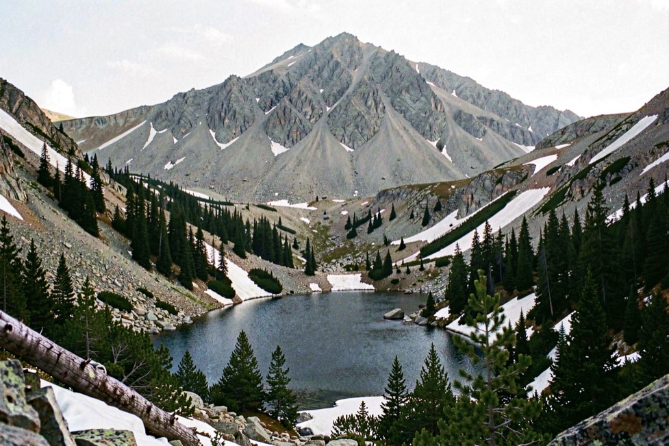
For most visitors the way in is the road that climbs east out of the city to the ski area. The hiking chapter sets out six trails above the city, with distances and elevation gain, from an hour in the foothills to a full day on Santa Fe Baldy. In winter the same road leads to the ski basin, and the ski chapter explains how Ski Santa Fe keeps its snow this far south.
06 Five life zones in a single climb
Climbing from the Plaza to the top of Santa Fe Baldy takes you through every forest belt the northern mountains have. New Mexico Magazine describes five life zones for them, with the caution that the boundaries are approximate guides rather than fixed lines.
- Piñon-juniper, 6,000 to 7,500 feet. The low, rounded trees of the foothills. Santa Fe itself sits near the top of this belt.
- Ponderosa pine, 7,500 to 8,500 feet. Tall, widely spaced pines, usually on the drier ground.
- Mixed conifer, 7,500 to 9,500 feet. Fir, spruce and pine together, with aspen in the moister places.
- Spruce-fir, 9,000 to 11,500 feet. Dense, dark forest of spruce and subalpine fir.
- Alpine, 11,500 feet and above. No trees at all: low shrubs, grasses and small flowering plants on wind-scoured ridges.
The overlapping figures are not a mistake. The belts interleave, and a cool north-facing slope holds forest types lower down than the sunny south-facing side of the same ridge.
Two seasons are worth planning around. The aspens turn gold from late September into the first half of October, and from July to mid-September thunderstorms build over the peaks on most afternoons, which is why anyone heading above the trees starts at first light and turns back by noon.
07 Pueblos, villages and a lake given back
People lived along the foot of these mountains long before anyone named them. Taos Pueblo sits under the Taos Mountains, with Pueblo Peak rising directly above it, and the pueblo was inscribed on the UNESCO World Heritage List in 1992. Much of the central Taos Mountains is Taos Pueblo land, including Blue Lake, which the pueblo holds sacred. Early in the twentieth century the federal government took the mountain land into what became Carson National Forest. In 1970 Public Law 91-550, signed by President Nixon, returned 48,000 acres including the lake, and a further 764 acres followed in 1996.
Further south, Spanish colonial villages grew up in the foothills: Chimayó, Córdova, Truchas and Las Trampas, today strung along the High Road to Taos, the slow way north from Santa Fe. Truchas shares its name with the peaks above it.
Travellers on the Santa Fe Trail met the range from the other side. The Spanish Peaks marked their first sight of the Rocky Mountains, and the trail's last leg into Santa Fe crossed the mountains at Glorieta Pass, the same gap the interstate uses now.
08 The range at a glance
- Name
- Sangre de Cristo Mountains, Spanish for the blood of Christ, in use since the early nineteenth century
- What it is
- The southernmost subrange of the Rocky Mountains
- Where
- Southern Colorado and northern New Mexico, from Poncha Pass to Glorieta Pass
- Length
- About 242 miles north to south, up to about 120 miles across
- Highest point
- Blanca Peak, Colorado, about 14,350 feet
- Highest in New Mexico
- Wheeler Peak, 13,161 feet, in the Taos Mountains
- Above Santa Fe
- The Santa Fe Mountains, with Santa Fe Baldy at 12,622 feet
- Protected land
- The Pecos, Wheeler Peak and Latir Peak wildernesses in New Mexico; the Sangre de Cristo Wilderness and Great Sand Dunes National Park and Preserve in Colorado
09 Three short answers
Are the Sangre de Cristo Mountains part of the Rockies?
Yes. They are the southernmost subrange of the Rocky Mountains, running about 242 miles from Poncha Pass in Colorado to Glorieta Pass, just southeast of Santa Fe.
What is the highest peak in the Sangre de Cristo Mountains?
Blanca Peak in southern Colorado, at about 14,350 feet. In New Mexico the highest point of the range, and of the state, is Wheeler Peak, at 13,161 feet, northeast of Taos.
Which part of the range do you see from Santa Fe?
The Santa Fe Mountains, the last section of the range. Santa Fe Baldy, at 12,622 feet, is the highest of the summits directly above the city, and the Pecos Wilderness lies behind them.